Therion Protractor
Cave surveying tool
Stacho Mudrak, Martin Budaj
July 20, 2000
This page is dedicated to cave surveyors, who:
- are not satisfied with the precision of free-hand sketches of a polygon
drawn directly in the cave
- have not enough time to compute reduced shot length (or survey stations
coordinates) by calculator/computer
in the cave or reduce this length graphically in the margin of the sketch
sheet
Solution is very simple: Therion protractor. Put it once on your
sketch and draw next shot in correct bearing with length reduced to horizontal
plane in your prefered scale.
How does it work
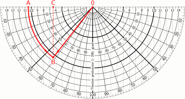
Example: suppose you have measured following shot:
- length: 10.5 m
- bearing: 20 grades
- inclination: 58 grades

- put the protractor origin (point 0) on the last drawn station
and rotate it to required bearing (like with ordinary protractor)
- find unreduced lengt from 0 (i.e. point A)
- imagine an arc with radius 10.5 m (starting at A) --
in the picture marked red
- imagine a segment with slope 58 grades from origin -- marked red
- find intersection (point B) of arc and segment
- using parallel vertical lines find reduced length (point C)
Reduced length is approximately 6.4 m
(exact formula gives 10.5*cos(58) = 6.436)
Short FAQ:
- Precision?
- With a bit of practice about 0.5 mm / survey shot, as good as other
commonly used methods. "Absolute" precision is not the purpose; precise
maps (with closed loops) are generated by computer.
- Is it not too slow?
- It's much more faster then computation or graphical reduction
- I need different scale or length/angle units.
- Some standard combinations are in downloadable pdf file. In the future
we will add customizable MetaPost source code (in terrible state,
not commented yet).
- How to make it?
- Print it on transparency and laminate it.
- Is it free?
- Yes.
- How to get it?
- Download here.
Updated: November 16, 2006

