Scraps and maps do not need to be tied with surveys
Note
Bruce Mutton wrote extensive information on this topic in Bruce's Data Structure. But there are a few details, I think, that should be noted.
Scraps and maps in Therion
The standard convention when drawing a map is to mimic (or follow) the surveys and related sketches. ie the file(s) containing the scrap drawings correspond more or less with the files containing the survey data. However in Therion you are absolutely free:
- One scrap may contain stations from several surveys. For instance, you may do this because such a scrap is more logical for map definitions.
- Maps are independent from the survey structure too: you may define maps as you need to create logical, easily understandable maps.
- You may define as many maps as you want, based on one (or more)survey set(s); from a map including only one scrap to complex maps of systems and areas.
- You may define a map which contains two nearby scraps from two different caves if they are in one survey structure, for instance to focus on looking for possible connections.
- You may divide a long slanting tunnel intersecting three horizontal levels, into three scraps and define a map which follows the horizontal structure AND a map which contains only those three scraps of that slanting tunnel. You can then choose to output either (or both) of those maps.
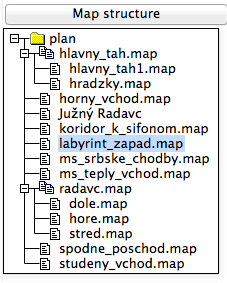
The main condition is the command “select” in the “thconfig” file which defines which map definition to use. A simple way to write such “select” commands is to double-click on the name of the required map in the “Map structure” section on the right/left side of the “Compiler window”.
Hint: Always define map(s) and use the “select” command in thconfig!

