Collecting the data
Processing the data
-
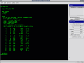
Enter the centreline data in the integrated editor or import existing centreline in Survex or Compass (PLT) format. It’s possible to combine both approaches. This step should be familiar for anybody who used any cave-surveying software. The input language is very similar to the language of Survex.
-
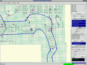
Draw the map in the integrated map editor. The cave map is split into simple sections called scraps. Each scrap contains survey stations, which are used during the output map generation to align the scrap with centreline (the scrap is “morphed” on the fly, the original data is never changed). There are three kinds of symbols which allow describing anything in the cave: points (station, stalactite, label...), lines (wall, pit, rock border...) and areas (water, sand...). You don’t need to draw them exactly, only to specify which kind of symbol it should be (e.g. you don’t draw a pit as a line with small ticks on one side, but only draw a line and specify as its attribute that this line should be displayed as a pit). All the symbols are rendered only during the map generation, just after the scraps are morphed. This allows easy switching among different map symbol sets (e.g. UIS and your local symbol set, if you define it) and adapt all map symbols to particular output scale.
-
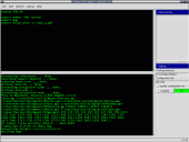
Run the Therion engine which generates the maps and models. Therion reads the centreline, closes loops and distributes errors. Then it reads scraps, transforms them to fit the centreline and joins them smoothly, reads the definition of the symbol set which should be used and renders the map. Then traces all the passage walls from the map and creates very detailed 3D model. All computations are hidden from the user, she only needs to draw scraps of the map as described in step 2.
-
Display the map in the viewer (currently PDF and SVG formats for 2D maps;
Therion, DXF, VRML, 3DMF, Survex and Compass formats for 3D models are supported).
-
Optionally use an SQL database engine to analyse the centreline information – Therion exports it in SQL format.
|


